
Resultados de la búsqueda
Para más opciones de búsqueda, vea Ayuda:Búsqueda.
Quizás quisiste decir: shade review map
Si consideras que este artículo debería existir, conoces nuestros pilares, dispones de fuentes fiables y sabes indicarlas como referencias, puedes crearlo, opcionalmente usando nuestro asistente.
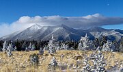 Commons alberga una categoría multimedia sobre Sierra de San Francisco. Shaded relief map of the Peaks, showing locations of the principal peaks San Francisco…3 kB (225 palabras) - 10:40 11 may 2023
 USGS Astrogeology Research Program, Craters USGS Staff. «Phobos Map – Shaded Relief». USGS. Consultado el 18 de agosto de 2013. Moore, D. (2000). Mars…36 kB (3366 palabras) - 22:03 25 ene 2024


Resultados de la Wikipedia en inglés.
- Terrain cartography (redirección desde Relief-Shaded Elevation Map)adapted from Computer graphics that adds a layer of shaded texture to the shaded surface relief that imitates the look of the local land cover. This…25 kB (2863 palabras) - 17:47 7 may 2024
- A geologic map or geological map is a special-purpose map made to show various geological features. Rock units or geologic strata are shown by color or…12 kB (1560 palabras) - 21:30 16 nov 2023
- ways of representing relief, such as shades, the result being a shaded hachure map; an example of such a map is the Dufour Map of Switzerland. Emil von…6 kB (676 palabras) - 18:43 7 oct 2023
- "Topographic map of Cerro Aconcagua". opentopomap.org. Retrieved June 10, 2023. "The North American Cordillera: A Color Shaded-Relief Map in Oblique Mercator…5 kB (358 palabras) - 07:08 19 abr 2024
- EU grant to tackle rural poverty in South Sinai Sinai trekking and safari: route maps and photo archive Archived 3 February 2015 at the Wayback Machine…41 kB (4181 palabras) - 14:50 21 abr 2024
- dissected plateau is a plateau area that has been severely eroded such that the relief is sharp. Such an area may be referred to as mountainous, but dissected…5 kB (454 palabras) - 02:23 4 feb 2024
- a topographic map or topographic sheet is a type of map characterized by large-scale detail and quantitative representation of relief features, usually…20 kB (2043 palabras) - 19:20 2 may 2024
- activities and resources. Encyclopedia of Oklahoma History and Culture - Arbuckle Mountains Oklahoma Digital Map Collection at Oklahoma State University…10 kB (882 palabras) - 20:22 1 abr 2024
- was confirmed and mapped at higher resolution with later orbiters such as Lunar Prospector and GRAIL. Shaded Relief map Gravity map based on GRAIL Like…16 kB (1832 palabras) - 16:18 30 mar 2024
- other tectonic structures related to the Crooked Creek crater on a shaded relief map Impact crater/structure Confidence Confirmed Diameter 4.3 mi (7 km)…2 kB (94 palabras) - 16:41 2 oct 2023
- (PDF) (Map). Scale not given. Chandler: Arizona Railway Museum. Retrieved August 1, 2008. DeskMap Systems (2005). Arizona Eastern Railway (PDF) (Map). Scale…68 kB (8460 palabras) - 18:28 5 abr 2024
- younger flows labeled, as seen by HiRISE under HiWish program MOLA shaded-relief maps showing location of Alba Mons Alba Mons, located in the northern Tharsis…56 kB (6549 palabras) - 16:49 12 may 2024
- within the Cumberland Plateau and Allegheny Plateau regions. Though the relief is not high, the plateau region is extremely rugged in most areas. The average…183 kB (17 997 palabras) - 16:26 15 may 2024
- August 17, 2019. Retrieved April 7, 2016. New Hampshire Coastal Access Map (PDF) (Map). New Hampshire Coastal Program. Archived (PDF) from the original on…126 kB (11 594 palabras) - 06:49 16 may 2024
- projects. 1702 map of Lake St. Clair Aerial view of Anchor Bay at Lake St. Clair Lake Erie and Lake Saint Clair bathymetric shaded relief map Frozen Lake…21 kB (2007 palabras) - 18:46 19 may 2024
- led to the complete collapse of the state's infrastructure. According to relief workers, the neighborhood of Los Corales was buried under 3 metres (9.8 ft)…27 kB (3337 palabras) - 19:18 22 abr 2024
- bounded by Ethiopia's Afar Region. Eritrea was also accused of redrawing the map of the area. Eritrea denied both claims. The conflict worsened until May…65 kB (5817 palabras) - 08:11 21 may 2024
- place as "Jefferson Range" on the maps that were just two years older. The 1947 Bozeman 1:250,000 shaded relief map has Jefferson Range, but the 1958…9 kB (1165 palabras) - 21:25 3 abr 2024
- Shaded relief map of Brukkaros Mountain…5 kB (537 palabras) - 08:55 9 ene 2024
- Press. ISBN 978-0-521-54414-6. Wlasuk, Peter T. (2000). Observing the Moon. Springer. ISBN 978-1-85233-193-1. LAC-1 area - Map of northern lunar pole…8 kB (793 palabras) - 05:53 19 abr 2023
- Shaded relief map of Uruguay…25 kB (3201 palabras) - 02:00 3 mar 2024